The Lakeside Life Blog
Smith Lake Alabama | Lewis Smith Lake Alabama
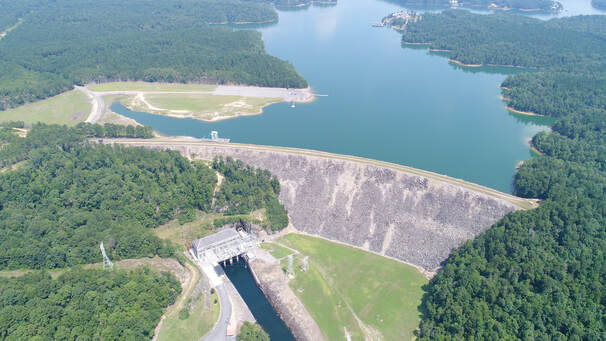 Photo: The Lakeside Life Magazine, Scott Hanna Photo: The Lakeside Life Magazine, Scott Hanna HISTORY - THE BUILDING OF LEWIS SMITH LAKE AND LEWIS SMITH DAM The Lewis Smith Dam of Alabama Power Company ("APC") and its powerhouse have been faithfully supporting and maintaining the Lewis Smith Lake Reservoir for over 6 decades. Both the dam and powerhouse were brilliantly designed specifically for harnessing and distributing hydro-electric power, to assist river conditions on the Sipsey to the Black Warrior trek, to help preserve overall water health and water levels on both sides of the dam, and lastly for anticipated recreational use and enjoyment. All of these initial requirements for the project were wonderfully accomplished while also preserving tracts of land around the facility and southern lake basin not only for future protection of the project itself, but also for the benefit of regional flora and fauna, and eventual community expansion. The cherished Black Warrior River served southern Alabama well during the earlier years of the area, and moreso for Native Americans very long before the area was even declared a state. As time progressed, the resource developed to be commercialized as both a waterway for industry and basic transportation during the state's growth. However, water levels along the route were never easy to count on, always dependent upon fickle mother nature and her natural gifts of things like geographical composition, rainfall and weather conditions. Over time, the gorgeous rock bluffs and rocky nature of the river shorelines and bed, which are part of the river's famed historical charm, caused the route to be hazardous and difficult for advanced commercial use north of Tuscaloosa. As the state matured and sought natural resources for power and fuel, valuable coal deposits were discovered northward of Tuscaloosa. Eventually this led to a time when coal industry shortages compelled the federal government to help assure safe and timely travel/transport through the area. By late nineteenth century, it was necessary enough that the government began digesting the concerns of the state and its industrial and commercial magnates resulting in the government setting out to improve the route with locks and dams north of Tuscaloosa with a prime goal to assist transportation and travel. Improvements along the river were helpful to industry, but there was more the river could provide, especially considering there was still lack of confidence in the long term traversing of an area that still relied heavily on natural conditions to keep water levels acceptable. By the mid-twentieth century, APC had begun considering benefits that could be provided to the state if a dam and lake near the head of the Black Warrior could be installed and bring forth an additional valuable source of power, among other things, while helping control water levels downstream. Additionally, Birmingham and the surrounding area could certainly benefit from a controlled source of water for residential and commercial use. By the mid 50s, it was a plan that APC felt compelled to push forward and did so by filing a formal application with the Federal Power Commission on July 27, 1954, to obtain permission to construct various hydroelectric projects along the Black Warrior River and above it. The location of the Sipsey Fork just east of the Jasper, AL area (aka "Upper New Hope") was a perfect site selection for APC engineers and architects to consider as the base for a dam and powerhouse location. A primary reason for considering the area was its rural nature, low population and ideal conditions with many natural streams and creeks feeding into the region. The geographical conditions were simply an excellent fit. 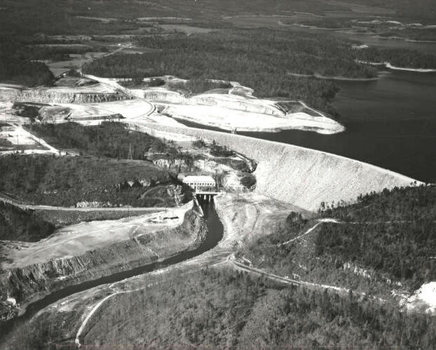 Smith Lake Dam under construction. Photo: Alabama Power Company via AL.com Smith Lake Dam under construction. Photo: Alabama Power Company via AL.com The project began with the acquisition of huge chunks of land in and around the Sipsey Fork area lying central of three (3) counties (Cullman, Walker & Winston). The formal construction finally began by November 25, 1957 with a slow progression of land excavation below and on the projected shoreline edges of the lake bed, including clearing large tracts of trees at the shoreline areas to what would become a marine vessel navigable depth - while leaving some areas forrested in what would become the deeper areas of the lake (some did not get cleared on time due to the lake rising faster than anticipated, but more on that later). Alongside the shoreline and bed area preparation, construction was ongoing for key bridges (Big Bridge aka Phillips Bridge, Bailey's Bridge, Swayback Bridge and the most famous Duncan Bridge), as well as a few other bridges placed at optimal positions on well travelled roads - all assisting the main project endeavor of an approximate 2,200' long, 300' ft high earthen dam. The base of the dam is said to be near a quarter mile wide tapering to the top, literally a manmade mountain built carefully from the base up. 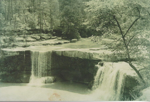 Clear Creek Falls, Photo: Smith Lake Concierge Clear Creek Falls, Photo: Smith Lake Concierge An interesting hitch in land accumulation was a very popular, although difficult to access, tourist area known as Clear Creek Falls in a small town known as Falls City, now under water just northwest of the present and popular Clear Creek Recreation area, and north of where Duncan Bridge now lies over the Sipsey. The tourist area consisted of two sets of falls, an upper falls and a lower falls. The small town had developed around the tourist area and actually had a post office and some residents that served and lived in the area. Before the dam construction began, the small town had become quite sparse, and was ultimately just too "out-of-the-way" for tourists. In fact, by 1953, the U.S. Postal Service had already stopped servicing the area, and the tourist area was in a slow state of decline. Important to note is that as land was purchased along the proposed lake area to build and fill the reservoir, there were small pockets of homes, barns, small buildings, farms, farm equipment, fencing, roads, etc., and even old graveyards. APC was happy to provide the honor and respect of relocating at least 78-80 graves from about four cemeteries known and reported to have been in the dam's flood zone area. 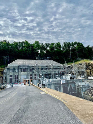 Photo: @wherewillwegonext Photo: @wherewillwegonext The earth and rock-filled dam is one of the largest of its kind in the eastern United States. As required for the project, the dam effectively impounded the Sipsey Fork of the Black Warrior River in the selected rock bluff and low mountainous area - if Googled you can see it lies in northwest Alabama at the heart of a foothills area, the Cumberland Plateau, and rises into the Appalachian Valley "Coosa Valley" from the southwestern end of the Appalachian Mountains. THE DAM AND POWERHOUSE The dam and lake were officially named Lewis Smith Dam (after Lewis Martin Smith, President of Alabama Power Company 1952-1958, who was very intricately and instrumentally involved in the planning, design and execution of the project) on May 23, 1961 - which was months before actual operation of the generators at the dam which finally occurred on September 5, 1961. The generators were put into operation once a satisfactory water level had been reached at the dam so that hydroelectric power could be collected. This happened much faster than anticipated. A record rainy season in summer of 1961 allowed the lake to fill miraculously fast, and to an acceptable level to place the generators in motion and christen the project. The two dates provided the dam and lake with two "birthdays" and both are celebrated as key dates in Smith Lake history. Situated at the southern tip of the lake between the Walker County and Cullman County border, with a Jasper address, the dam is not only a marvel of late 1950s to early 1960s engineering, but a very integral and efficient part of what makes Smith Lake the incredible place it has become over the last 60+ years. Without it, there simply would be no lake. It was a $29 million dollar project and a feat of great undertaking first by APC executives, engineers and architects with the Federal Government and in conjunction with the U.S. Army Corps of Engineers, and finally with the help from all the many unseen heroes - the outstanding construction workers who hailed from all around the local lake area and as far as the Birmingham, Decatur and Huntsville areas and beyond. The powerhouse is built of concrete, concrete block, and metal architecture with beautiful large, tall glass windows for interior staff to effectively observe operations. It houses and controls the two (2) massive generators rating 78,750 kilowatts each. The building is placed over the outlet point of the lake waters on the southwest side of the dam as the Sipsey Fork flows into the head of the Black Warrior River at the river's northernmost point. Water flows into the powerhouse below and south of the dam through two (2) tunnels at 26' in diameter and 1,925' long. Average annual electrical output from the generators was planned at 233,000 megawatt-hours, obviously depending on generator operation due to water condition control above and below the dam by nature itself. Of note, Smith Lake is not a constant source of electricity for APC, but was designed to provide additional power for peak demand or optimal market pricing. Hydropower is highly economical for APC as it has no need for fuel and is easily gathered, although considering that at any given time, only so much water would be pulled from the reservoir, always in consideration of what mother nature provides or needs in a given timeframe, and how best to control conditions above and below the dam. Hydro-generation was actually reduced through drought years during the early twentieth century, and events of that nature can occur any time. 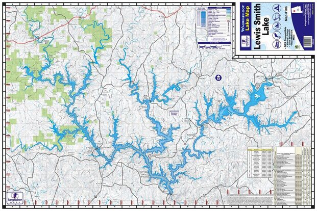 Photo: KF Maps - online LAKE SIZE As mentioned above, to the surprise of all involved in the project, the earlier than anticipated filling of the lake behind the dam after abundant rain in the summer of 1961 gave way to the beginnings of a lake that soon rose to the current average size/volume/length as listed below:
 LAKE LEVEL FLUCTUATION It's important to know that the water level of Smith Lake was designed in the beginning to experience averages in fluctuation from near 496', normal winter pool, to 510', normal summer pool. This would depend more or less on rainfall and watershed conditions. Fall and winter have consistently averaged as known rainy periods for the area through the decades. The drawdown average of about 14'-15' from late summer pool to winter pool was to be a very normal occurrence. Alabama Power Company has effectively operated an average generator schedule that can be seen on their site apcshorelines.com, or through their "Shorelines" app, where they have continued informing the community of water level conditions in recent times through the app and social media, and through traditional media for decades. The operations are perfectly normal, and careful considerations are always taken to remain protective of conditions on both sides of the dam as much as possible. As a result of this known level fluctuation, local property owners know to stay aware of what is known as the 522' mark on their properties (old mark was set at 520' with a new mark said to be at 524'). These marks become important in times of extreme weather and "acts of God," and property owners diligently keep watch on conditions during those weather events to provide timely maintenance for floating docks, cables, electrical systems, shorelines, and property along the shoreline or at/above flood levels. Only floating docks are allowed on Smith Lake due to these expected fluctuation periods. A good rule of thumb for most locals has been that for every 1' of rain, the lake can rise 1" within as little as 24 hours depending on heaviness of precipitation, ground saturation at the time of that type of event, and due to runoff that continually falls into the lake after the weather event. There is a spillway, a manmade built-in relief system, built across the road westward from the Smith Lake Dam boat launch area that would become operable at a 522' flood level, and amazingly to date it has never come into play and therefore remains a virgin emergency-only relief. Lake residents are very satisfied and relieved that the spillway has never had to be put to the test due to the overall very well-designed system.  Lewis Smith Lake, Rock Creek, Photo: JWB Photography, Jennifer Beckman Lewis Smith Lake, Rock Creek, Photo: JWB Photography, Jennifer Beckman Those who have owned property on the lake for decades are very familiar with this fluctuation and it is simply an annual occurrence on their property, but new property owners are often not as aware as they should be of the decades-old typical fluctuation. It's one of the facts "known" to those of who have been lake dwellers for a very long time, and simply a new fact to people who have never lived on a reservoir like Smith Lake. It's something that must be learned and dealt with as a property owner. A recent near flood period in early 2021 where the lake rose above 521' was still enough to get the attention of most folks in the area and the news outlets as well. However, the lake stayed safely below the flood level. Truly that type of event has consistently been a once-a-decade type occurrence. From our observation while living here over 25 years, in the early years of the lake, there just wasn't as much concern about the level since the lake was not as developed. The lake area was considered so rural for so long, and not that many people actually lived on the lake full time. Vacationers would come and go, but many areas were still difficult to reach. There were many years in the beginning where there was only one patrolman for the entire spanse of the lake. Locals who did live in the community-wide area full time knew that building high near shorelines was the norm, and simply enjoyed the geological change in properties at the shoreline as seasons progressed. Recently, the lake has become more crowded. Since about the mid-80s there has been a steady increase of residential and commercial development. Lakefront lots are very desirable, now even slough lots where water typically graduates into shallower zones at the back points of those sloughs are sought-after since they offer a respite from busy lake traffic on main channels. However, because of these locations becoming more popular, it has become more important to know where the 496' and 522' levels lie on any given property, if for no other reason than for the proper positioning of floating docks allowed only with permit from APC. This is why interested buyers seeking property should actually view properties in the fall and winter. It's just as important, if not moreso, than in the spring and summer months. By viewing property in the fall and winter, potential buyers can observe shoreline conditions at their lowest and not just highest water levels. A positive is that many locals feel they have more lovely property to explore when water level is lower. 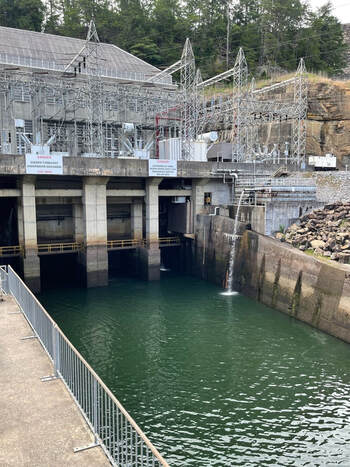 Photo: @wherewillwegonext Photo: @wherewillwegonext To begin our wrap-up - let's remember, primarily, the lake was created as a source of energy, so its history simply began with the need for hydroelectric power. However, it now also provides flood control, recreation, economic opportunity, irrigation and drinking water, plus it is a fish and wildlife habitat as nestled on its northwest end into the southern side of the treasured William B. Bankhead National Forest which holds the Sipsey Wilderness Area and the all important clean and clear headwaters of the lake. Check out our blog on "Things to Do" in the lake area for more specific information about all that the lake provides for recreation.
 Photo: Seibels (purchase from Seibels and frame) Photo: Seibels (purchase from Seibels and frame) The lake's accessibility to key cities like Birmingham, Huntsville, Decatur, Nashville and Memphis has increased the lure of vacationers and vacation property seekers. The lake has become very well known in the last decade for its very deep clear waters, excellent fishing and general recreation. Check out our blog on Things to Do and See on Smith Lake. In closing, we ask readers to just think about the overall project of Smith Lake - the sheer size of the lake and the miles of shoreline. Can you imagine this area having never been created by the efforts of APC? We can't imagine it not being here because once you're here, you realize it seems like a natural God-given resource, and considering the talent it took to make it come to fruition, it IS a God-given gift after all. TOUR THE DAM Did you know that you may contact the APC Powerhouse facility for a scheduled tour or visit? Contact info is below: Lewis Smith Dam, Alabama Power Company 640 Powerhouse Rd. Jasper, AL 35504 205-384-7385 Hours: Usually open Mon-Fri, 7am-2pm by appointment Tours are scheduled ONLY by appointment This article is written in appreciation with thanks to Alabama Power Company for its design, creation and maintenance of the powerhouse at the Lewis Smith Dam and all that APC provides for the Lewis Smith Lake reservoir. Writers: The Lakeside Life Magazine Team, published: 09/05/2017 (updated: 01/15/22) Additional Resources Writer: Sznajderman, Michael. Lewis Smith Dam and Lake. Encyclopedia of Alabama, 2008. Writer: Atkins, Leah Rawls. Developed for the Service of Alabama: The Centennial History of The Alabama Power Company, 1906-2006. Birmingham: Alabama Power Company, 2006. Writer: Willis, Kenneth D. "The Harnessing of the Black Warrior River." Alabama Heritage 33 (Summer 1994): 19-25. Alabama Power Company, its archives and site APCShorelines.com
0 Comments
|
ABOUTLake Living at it's best! CategoriesAll 4th Of July About Us Advertising Advice Alabama Gulf Coast Alabama Power Company Apparel Boating Boating Safety Clothing Cocktail Cookbook Digital-edition Digital-edition Docktail Fall On Smith Festival Fishing Food & Drink Giveaway Hats Homes On Smith #HowILake Lake Advice Lake Clothing Lake Decor Lake Gear Lake Goods Lewis Smith Dam Lewis Smith Lake Life On Smith Logo Magazine Info Marketing Modern Living Music Music Festival Recipe Recipes Recreation Roadtrips Safety Sides Smith Lake Smith Lake AL Smith Lake Alabama Smith Lake Business Smith Lake Businesses Smith Lake Events Smith Lake History Smith Lake Holidays Smith Lake Homes Smith Lake Life Smith Lake People Smith Lake Sports Smith Lake Things To Do Social Media Sports And Recreation Spring Subscribe Subscriptions Summer The Lakeside Life The-lakeside-life The Lakeside Life Brand The-lakeside-life-team The-lakeside-life-team Things To Do Travel Travel Alabama Archives
June 2024
|
 RSS Feed