SMITH LAKE ALABAMA MAPS
Coming soon... our Smith Lake Map!
In the meantime, enjoy the excellent map options below.
In the meantime, enjoy the excellent map options below.
SMITH LAKE MAPS TO PURCHASE
1. Utility maps - also great for framing - we recommend the maps below for purchase:
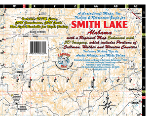
Carto-Craft Map (made in Birmingham AL), order online: cartocraft.com
or visit their shop in Birmingham: Carto-Craft Maps, Inc. 738 Shades Mountain Plaza Hoover, AL 35226 (205) 822-2103 |
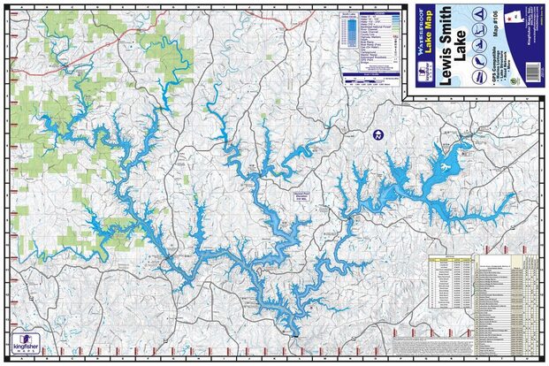
KingFisher Maps, order online: kfmaps.com
|
2. Home Decor - the maps above can be framed quite easily, and some like the rustic style. However, if you are looking for something more decorative, please try the local stores below to see if they have something in stock, can order something for you, or can find something for you.
If you would like a very personalized map or customized piece of art, you can check with our local group "Lewis Smith Lake Artisans Alliance" to request a piece of commissioned art or drawing.
SMITH LAKE GPS MAP APP
|
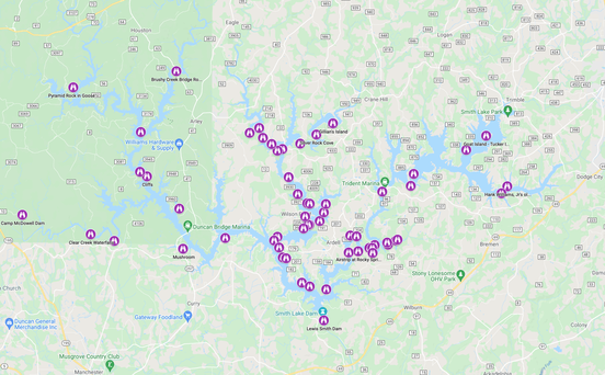
Local White Pepper Real Estate Realtors Brian Glenn & Darren Raspino of Jasper, AL created a copyright interactive map/app for use on any desktop, laptop or mobile device. Download it, save it to your iPhone and share it with your Smith Lake loving friends & family!
Find the map/app at this link: SMITH LAKE GPS or go to their website smithlakegps.com , and also find info on the it via Facebook as @smithlakegps and on Instagram as @smithlakegps. You may also reach them at the following email: [email protected] |

Click photo for the Smith Lake GPS Map App - download to your phone
|

|
The map updates often on their site. So, use it and enjoy finding not only local spots and info (somewhat similar to our map - although ours is more relative to our magazine and social media content), but also find waterfront homes for sale, lots/land for sale, food/fuel/fun and more – all by exact GPS location.
Also, be sure to check out their other site on Facebook "Safer Smith Lake" where you can order a high quality sign to safely identify your dock and property location in any emergency situation for Marine Patrol or friends & family. |
LEWIS SMITH LAKE GOOGLE MAP

|
One of our favorite local residents on Smith Lake is Mrs. Sue Clements. If you meet her online or in person, you are going to fall in love...trust us on that. She's one of the good ones... no, actually, she is one of the great ones.
One of her favorite things to do upon moving to Smith Lake was to find out everything she could about the area. In doing so, she began to form a Google MyMap that would help her find places to visit around the tri-county area. Her travels about the lake became so extensive that her collected information and map grew to the point of becoming a link that she wanted to share with others. |
|
As noted on her Facebook Group "Exploring Lewis Smith Lake" she created the group to:
1) Share her Google MyMap of the Lake 2) Share her Places to Files Links: Introduction to the map Places to Files: tinyurl.com/LSLLinks Instructions for using the map: tinyurl.com/MyMapIns Link directly to the Map tinyurl.com/MyMapLSL If you would like to download a copy of the data point, you can do so at: https://drive.google.com/.../1zCqN.../view Contact Sue via email: [email protected] |
Click photo for the Lewis Smith Lake Google Map by Sue Clements.
Head over to her links and see if the map information helps you. See Sue's basic instructions to use her map below. Join her Facebook Group page named "Exploring Lewis Smith Lake." You may also reach her by messaging her through Facebook.
|
|
Instructions for using Sue's Google Map of Lewis Smith Lake
The map is broken down into the these categories: · Main Waterways · Tributaries · Bridges · Landmarks · Launches · Lodging, Camps, & Parks · Marinas · Restaurants on the water · Subdivisions · Points of Interest When the map is first opened it will not show any details.
Once a category(s) is chosen, click on the down arrow just below the check box to see a list of locations in that category. Clicking on an item in the list will cause the icon for that item to be highlighted on the map and the information for that item will be displayed. A '?' after a name indicates that we do not have the location. In some cases, they are mapped to the vicinity. If unknown, we mapped them in a straight line starting in Addison and going south. If you know the location/coordinates, please message Sue. |
The Waterways category in previous versions of the map has been divided into “Main Waterways” and “Tributaries.” To see all waterways on the map as it was in previous versions, check both categories.
Clicking on the magnifier, search the map table for a particular place (ie: Indian Head or Trident Marina.) Generally, the labels associated with the locations will be displayed next to their icon. If the zoom is such that the labels would overlap, only one label will show. Zoom in to see both labels or click on the icon to see the label. Google Map Limitations - Sue's Notes The map is initially built from a series of Excel files - one for each category. The categories in the map legend are listed in order that they are built into the map. To reconstruct a category from the excel file, you have to delete the category in the map and then import the excel file again. That category will then be at the end of the list. When the file is first built, the locations in each category are listed alphabetically. If you add a new location, it goes in at the top of the list and thus the items will no longer be in alphabetical order. Thus far, I have just been rebuilding the category so that they will be alphabetical, Pictures for the locations are added directly into the map. If a category is rebuilt from the Excel file the pictures are lost thus I will not be able to keep the categories or items in the categories in any particular order once I start adding pictures. |